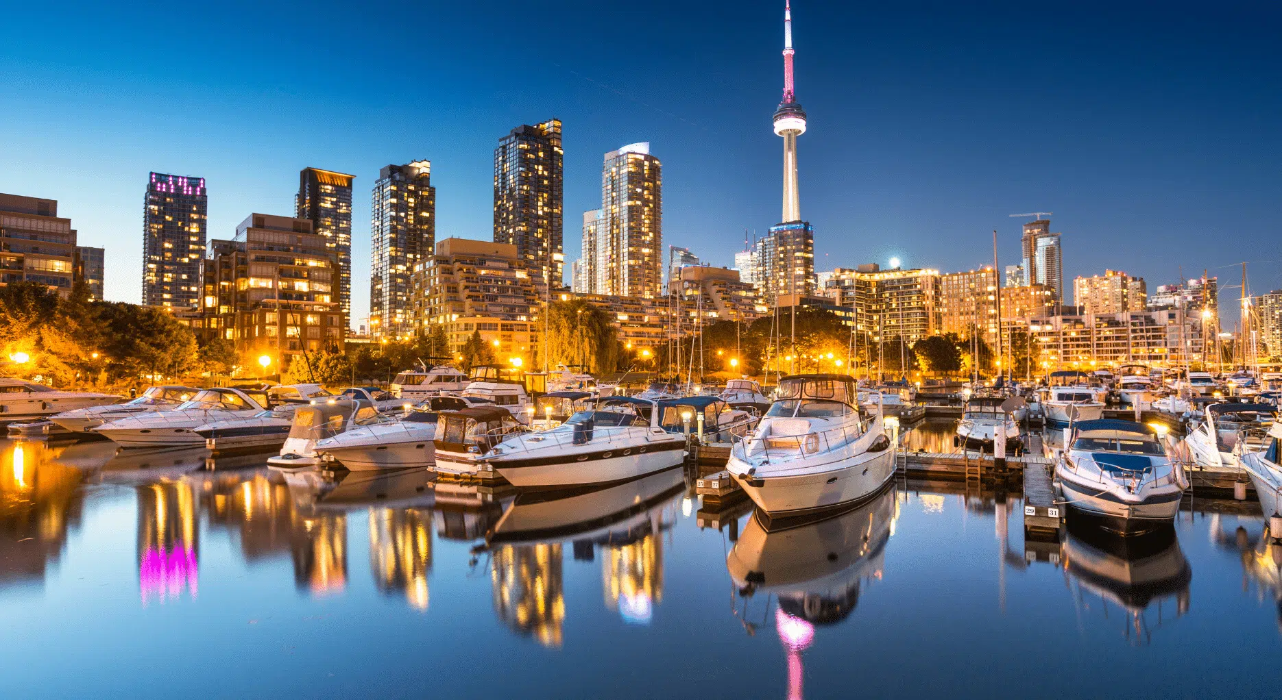

A privately arranged boat journey across Toronto Harbour offers a clear reading of the city’s development, from industrial port to contemporary waterfront. Moving between shoreline, islands, and open lake, the experience explains how trade, planning decisions, and ecology have shaped Toronto’s growth.
Toronto is often understood from land, where neighborhoods and institutions define the city’s identity. From the water, a different structure becomes visible.
A private harbor navigation follows routes once central to commerce and transport. Grain terminals, ferry channels, and former industrial sites sit alongside residential towers and public waterfront projects. The contrast is deliberate. Toronto’s modern skyline was built around access to Lake Ontario, and its future continues to depend on how that access is managed.
This is not a sightseeing cruise. It is a structured exploration of how a city grew outward from its harbor and how it continues to negotiate density, infrastructure, and environment along the water’s edge.

About Do Not Disturb
Do Not Disturb is a luxury travel company specializing in carefully designed journeys and considered experiences. Each itinerary we build for our clients is informed by real destination knowledge, offering insight into places, cultures, and moments that shape how a trip comes together.
If this destination has sparked ideas, the itinerary can be developed into a private journey tailored to your interests and travel style, with hand-picked stays, thoughtful routing, and experiences curated around what matters most to you.
Cultural and Urban Context
Toronto’s harbor has been central to the city since its earliest settlement. Access to Lake Ontario enabled trade with the Great Lakes and the Atlantic beyond, shaping Toronto’s role as a commercial gateway. Rail lines, grain terminals, and warehouses clustered along the water, defining the city’s industrial core.
Over time, shipping technology and global trade patterns changed. Port activity shifted east. Large stretches of waterfront land were left underused. The city responded gradually, repurposing former industrial zones into parks, housing, and mixed-use districts while retaining active port functions where required.
The Toronto Islands are integral to this story. Originally a peninsula, storms and erosion separated them from the mainland, creating a natural breakwater. Their continued protection limits development along the inner harbor, preserves navigation conditions, and shapes skyline views across the lake.
Understanding Toronto’s waterfront requires seeing these elements together. From land, they are disconnected. From the water, they form a coherent whole.

Why Private Access Matters
Shared harbor tours follow fixed routes and schedules, often prioritizing landmarks. A private boat allows the route to respond to interest and conditions. Time can be spent near the Port Lands to discuss land reclamation and flood protection. The boat can idle along island channels to explain ferry access and zoning limits. The pace adjusts to visibility, weather, and questions.
Private access also enables informed commentary. The guide focuses on specific decisions and outcomes rather than general description. The result is a clearer understanding of how Toronto manages growth, infrastructure, and environmental responsibility along its shoreline.

What You See
The journey typically begins in the inner harbor, where ferry routes intersect with commercial traffic. From here, the downtown skyline reads as a continuous edge rather than a series of isolated buildings. Height, spacing, and orientation reflect planning controls tied to views, wind, and access.
Moving east, the Port Lands illustrate Toronto’s industrial past and ongoing transformation. Former shipping and manufacturing areas sit beside large-scale flood protection works designed to safeguard future development. The scale of these interventions is most apparent from the water.
Along the Toronto Islands, the city’s planning priorities become explicit. Low-density housing, parkland, and limited services preserve the islands’ role as buffer and public asset. Sightlines back to the city reveal how this restraint shapes Toronto’s waterfront character.
Venturing briefly onto Lake Ontario provides context for exposure and scale. The city’s reliance on the harbor’s protection is evident, as is the importance of lake conditions in daily operations.

How Do Not Disturb Makes This Possible
Do Not Disturb curates private harbor navigation in Toronto with attention to route design, timing, and expertise. Boats are selected for comfort and maneuverability. Guides are chosen for their understanding of urban planning, trade history, and lake systems, translating complex topics into clear, practical explanation.
Toronto’s waterfront tells the city’s story more clearly than any single street or building. From the harbor, planning decisions, environmental limits, and commercial priorities align into a legible structure. A private navigation offers the perspective needed to understand how the city works, and how it continues to change.
Ready to plan a private harbor navigation in Toronto and explore the city from its defining edge? Speak with Do Not Disturb to begin your journey.
Plan your own version of this journey
Speak to Do Not Disturb’s luxury travel experts and turn this moment into something personal.
Related destinations
Suggested articles

The Rocky Mountaineer: Canada’s Most Luxurious Train Journey

Two Days in Montreal: Where to Eat, Stay and Explore
Beyond the Maldives: Seven Islands for a Different Kind of Honeymoon
Multi-Destination Honeymoons: The Best Pairings for Two Distinct Locations

Where to Go On Honeymoon? A Guide to Help You Choose

Wilderness to Waves: Luxury Honeymoons in Kenya

Luxury Safaris: Why Laikipia Is Kenya’s Best-Kept Secret
Positano vs Ravello: Where to Stay on the Amalfi Coast
Chianti’s Luxury Villas: Stay Like a Renaissance Noble

Romantic Florence: The Ideal Italian Honeymoon
Venice for Art Lovers: Palaces, Churches and Private Views

Experiencing Florence Without the Crowds

Lake Como vs Lake Garda: Which Italian Lake Is Right for You?